
15 Hawaiʻi Geospatial Information
Gwen Sinclair
Learning Objectives
- Develop an understanding of the history of land divisions and mapping in Hawaiʻi
- Learn about the various types of maps and geospatial data available for the state
- Become familiar with the most important sources of government geospatial information for Hawaiʻi
Hawaiʻi’s history and systems of land division make the state’s geospatial resources stand apart from those used in most parts of the country. This chapter will explain historic and current land divisions, government mapping, GIS data, and other resources for geospatial research in the state.
In the traditional Hawaiian system of land division, the largest land division is the island. Islands are divided into districts, or moku, which reflect traditional understandings of watershed boundaries. Moku are further divided into ahupuaʻa, surface water management areas or land management boundaries.[1] An ahupuaʻa is usually described as a triangular land division extending from the mountains to the sea. However, not all ahupuaʻa follow this scheme. Ahupuaʻa could be further subdivided into ʻili. Many 19th century maps reproduce these land divisions and are essential for understanding Hawaiian concepts of land division.
Early Government Mapping
Foreign Exploring Expeditions
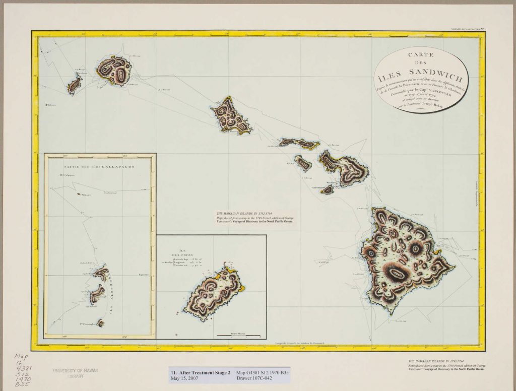
The first maps of the Hawaiian Islands showed the islands as viewed by foreigners, whose focus tended to be on charting coastlines to improve navigation and indicate safe harbors. The earliest maps of Hawaiʻi were produced during government exploring expeditions—but not by the United States; they were produced by members of Captain James Cook’s final expedition for the British Navy. Later in the 18th century, explorations conducted by La Perouse for France’s navy, Manuel Quimper of Spain, George Vancouver of the British Navy, and Joseph Ingraham of the United States resulted in additional early maps and charts. Additional charting by foreign government expeditions in the early 19th century increased knowledge of the coastal geography of the Hawaiian archipelago. Significantly, the U.S. Exploring Expedition headed by Charles Wilkes provided the first mapping of Hawaii volcanoes. Images of many of these early maps can be found in Fitzpatrick and Moffat’s The Early Mapping of Hawaiʻi and in other sources.[2]
Missionaries
Before the Hawaiian government began to sponsor mapping projects, missionaries created maps of the islands and students engraved and printed maps for teaching purposes at Lahainaluna Seminary in the early to mid-19th century. These represent the earliest maps created by Native Hawaiians, most notably by Simon P. Kalama.[3] Although these maps were not produced by the government, the seminary was extremely important because of its role in educating many future statesmen and surveyors. The experience of creating maps of the islands and the rest of the world greatly influenced later support for government mapping.
The Mahele
During the time of King Kamehameha I and his predecessors, the land belonged to the chiefs and the people in common. One of the most significant events in Hawaiian history was the Mahele, whose purpose was to enable private land ownership and clearly demarcate crown lands (land retained by Kamehameha III for himself and his heirs and assigns), government lands (lands set aside by Kamehameha III for the government), and konohiki lands (lands awarded to chiefs or land agents by the Land Commission or Mahele). The first step in this process was to establish the Board of Commissioners to Quiet Land Titles, known as the Land Commission. Its purpose was to determine the rights in land that existed at the time, to confirm claims, and to issue awards to claimants, upon which the Minister of the Interior would issue a Royal Patent.
The Buke Mahele of 1848 recorded the original division of lands between the king and the aliʻi. First, the king asserted his individual ownership of his private lands. Second, lands designated as government lands were also recorded. Third, claims could be submitted by aliʻi (chiefs), konohiki (land managers), and makaʻāinana (commoners). The makaʻāinana were awarded fee simple rights to lands, or kuleana, that they could prove they had cultivated for at least two years. When land sales to commoners and foreigners was implemented, these transactions were listed in Index of All Grants and Patents Land Sales. The Land Commission awarded lands on the basis of traditional names, without a survey having been conducted, in anticipation that the lands would be surveyed later. In the meantime, a commissioner of boundaries was established to hear testimony on land boundaries. The process of submitting claims to the Land Commission extended from 1848 all the way to 1895.[4]
The AVA (Ancestral Visions of ʻĀina) Konohiki project of the Kamakakūokalani Center for Hawaiian Studies at the University of Hawaiʻi at Mānoa teaches students to understand land documents, create metadata, transcribe, and upload them to the website. The project makes available the Buke Mahele, Foreign Testimonies, Native Testimonies and associated indexes, ahupuaʻa maps, and Land Claim Award index images and transcriptions.[5] The same documents are searchable through the Office of Hawaiian Affairs’ Kīpuka Database, which “links historic data sets to geographic locations perpetuating the concept of information embedded in the ʻāina (land) and encoded in wahi inoa (place names).” It is a GIS relational database that merges datasets related to Native Hawaiian land, culture, and history. Layers included in the database include historic sites, land awards, government lands, crown lands, trust lands, moku, ahupuaʻa, ʻili, and tax map keys.[6]
State Survey Maps
The Hawaiian Government Survey (HGS) was created by the legislature in 1870, primarily to delineate the Government lands, which formed the tax base of the Kingdom. In addition, the survey was needed to accurately describe parcels that had been inaccurately surveyed during the Mahele, resulting in many disputes over boundaries. Surveying was a lengthy process, however, and it took decades to create maps of each island.[7]
The HGS maps are very detailed and offer a snapshot of land divisions, agriculture, land use, towns, natural features, and other geographic characteristics at the time the survey was conducted. Researchers interested in fishponds, for example, will find these maps highly useful, for they depict the boundaries of the ancient fishponds that once were a common feature of many shorelines. Many of the small-scale maps (those showing entire islands or large portions thereof) are color-coded to distinguish government lands, crown lands, and private lands.
The Hawaiʻi State Land Survey Division holds a treasure trove of HGS maps created during the Kingdom and later periods. Currently, online access to scanned images is available through a clunky interface that requires the user to use an index to find the registered map number to retrieve the desired map. A new interface is under development to allow searching by keyword and location, and will eventually host not only PDF files but also tif and jpg files.

Modern Government-Produced Geospatial Information
Aerial Photographs
Aerial photographs are important sources of information about land use, land cover, historical and archaeological sites, coastal morphology, and human settlements. At various times in the 20th century, the USDA, USGS, NOAA, and NASA have produced aerial photographs of various parts the state. Digitized photos can be found on the MAGIS website hosted by the University of Hawaiʻi at Mānoa Library. Additional photographs that have not been digitized or that have not been published online can be obtained from MAGIS.
Satellite Imagery and GIS Data
MAGIS has created a handy guide to satellite imagery and GIS data for Hawaiʻi. There, one can find links to imagery for coastal geology, , weather, and other topics.
Honolulu Open Geospatial Data
Researchers can find data for flood zones, wetlands, zoning, transportation, political subdivisions, parks, and other topics in the Honolulu Open Geospatial Data portal. Users may download shapefiles or create web maps.
State of Hawaiʻi
The Hawaiʻi Statewide GIS Program provides downloadable files covering a variety of thematic and political realms for use in GIS systems. Users who do not have GIS software may download free GIS viewer software in order to view the shapefiles.
Land Records
Land Transactions
Hawaiʻi is the only state with a statewide office, the Bureau of Conveyances (BOC), that records land transactions. Currently, documents recorded from 1992 to 60 days prior to the current date can be found online, but downloads cost $1 per page. Documents recorded prior to 1992 may be researched in the BOC’s Public Reference Room. The BOC is in the process of digitizing historical documents but they are not yet available online. The BOC also has helpful research aids such as grantor-grantee indexes and a cross-reference between Land Commission Award numbers and tax map keys.
The BOC records fall into two categories: Land Court and Regular. The “Land Court System provides State certification for the ownership of a property. Property is in Land Court if it was registered with the State at some point since the 1900’s. Conversely, all non-registered properties are part of the Regular System.”[8]
Parcel Information
Each county’s parcels are shown on tax maps, which are numbered using a system called tax map keys (TMKs), which uses a 9-digit format. The first digit is the county code, with 1 = Honolulu, 2 = Maui, 3 = Hawaiʻi, and 4 = Kauaʻi County. These are followed by a one-digit zone number, a one-digit section number, a three-digit plat number, and a three-digit parcel number. For example, TMK 118028009 means that the parcel is in Honolulu County, zone 1, section 8, plat 028, parcel 009. Occasionally, TMKs are written without the county code. These numbers are essential for using other geospatial tools to retrieve information about parcels of land.
Counties
The City and County of Honolulu provides the Property Records Search website that allows searching by street address or TMK. Users may download a PDF of a tax map or a GIS version of the parcel map, which provides the boundary lines in an electronic format. Be aware that the tax maps, which date to Territorial times, show historical ownership data in addition to the original grant numbers. In order to view the current ownership data, one must consult the database listing (“card”). The parcel information in the database shows the current owner, acreage of the property, size of the improvements, property value, and even a sketch of the buildings on the parcel.
- In the County of Hawaiʻi, the Real Property Tax Division hosts Hawaiʻi County Subdivision Maps and Hawaiʻi County Property Search.
- The Kauaʻi Real Property Tax website is the interface to search for Kauaʻi County parcel information.
- Maui County’s parcel information may be found at its Real Property Tax Assessment site.
Librarian’s Library
Fitzpatrick, G. L. & Moffat, R. M. (1986). The early mapping of Hawaiʻi. Honolulu: Editions Limited.
Moffat, R. M. & Fitzpatrick, G. L. (1995). Surveying the Mahele: Mapping the Hawaiian land revolution. Honolulu: Editions Limited.
Moffat, R. M. & Fitzpatrick, G. L. (2004). Mapping the lands and waters of Hawaiʻi: The Hawaiian Government Survey. Honolulu: Editions Limited.
This trio of books by map librarians Gary Fitzpatrick of the Library of Congress and Riley Moffat of Brigham Young University-Hawaii cover the early mapping of Hawaiʻi by both government and non-government surveyors and cartographers. Images of many of these early maps have been reproduced in color.
Hawaiʻi Office of State Planning. (1988). Directory of maps and geographic information in Hawaii. Honolulu: Office of State Planning.
This guide lists libraries, archives, and museums that maintain map collections as well as businesses that sell maps. Although dated, it is still a useful guide to the major map repositories in the state.
Pukui, M. K., Elbert, S. H., & Mookini, E. T. (1974). Place names of Hawaii (Rev. and enl. ed.). Honolulu: University of Hawaiʻi Press.
The most authoritative work listing the spellings and origins of place names.
Clark, J. R. K. (2002). Hawaiʻi place names: Shores, beaches, and surf sites. Honolulu, Hawaii : University of Hawaiʻi Press.
Clark’s book concentrates on coastal place names and is an important source for historical names of modern places.
Lucas, P. F. N. (1995). A dictionary of Hawaiian legal land-terms. Honolulu: Native Hawaiian Legal Corporation.
A glossary of Hawaiian and English legal terms that may be found in documents related to land. Includes facsimiles and translations of examples of a Land Commission Award, a Royal Patent, a Royal Patent Grant, a Mahele Award, and other documents related to land transactions.
Reverend Joel Hulu Mahoe Resource Center. (1997). A research manual on information access and retrieval of genealogical and land information from government repositories in the State of Hawaii. Waipahu, HI: The Reverend Joel Hulu Mahoe Resource Center.
This volume contains a wealth of information for genealogy researchers, especially with regard to land records. It explains the land records in various repositories and contains a list of abbreviations and a glossary of terms.
William S. Richardson School of Law Library. Hawaiʻi legal research: Land research. https://law-hawaii.libguides.com/c.php?g=125434&p=4485821
A comprehensive listing of resources relevant to land research in Hawaiʻi.
- Kameʻeleihiwa, L. (2015). Oʻahu fishponds lecture. http://www.avakonohiki.org/270-videos.html ↵
- Fitzpatrick, G. L. & Moffat, R.M. (1986). The early mapping of Hawaiʻi. Honolulu: Editions Limited. ↵
- Fitzpatrick & Moffat (1986). ↵
- Moffat, R. M. & Fitzpatrick, G. L. (1995). Surveying the Mahele: Mapping the Hawaiian land revolution. Honolulu: Editions Limited. ↵
- Louis, R. P. with Kahele, M. (2017). Kanaka Hawaiʻi cartographies. Corvallis: Oregon State University Press. ↵
- State of Hawaiʻi. Office of Hawaiian Affairs. (2015?). The Kīpuka database fact sheet. Honolulu: Office of Hawaiian Affairs. ↵
- Moffat, R. M. & Fitzpatrick, G. L. (2004). Mapping the lands and waters of Hawaiʻi: The Hawaiian Government Survey. Honolulu: Editions Limited. ↵
- Hawaiʻi. Bureau of Conveyances. FAQs. https://dlnr.hawaii.gov/boc/faqs/ ↵
Bathymetry refers to submarine topography, or the hills, valleys, chasms, and other features of the ocean floor.
